Caribbean Tectonic Activity Map PNG
A scientific map showing tectonic plate movement in the Caribbean region with arrows and seismic markers.
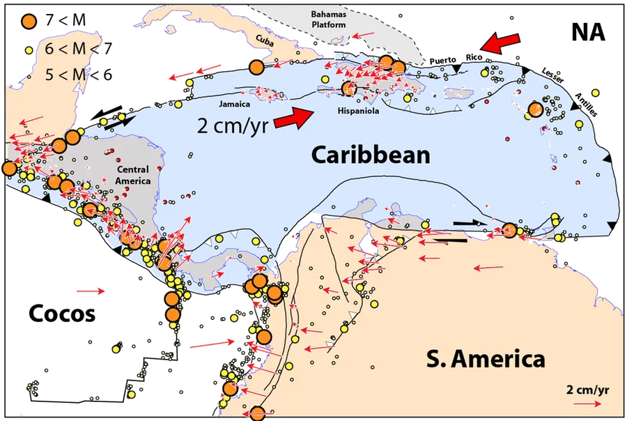
Image details 986 × 662 · PNG · Beige
Size and format
- Resolution
- 986 × 662 pixels
- Megapixels
- 0.65 MP
- Aspect ratio
- 3:2 · Landscape
- Best for
- Desktop and laptop screens
- File format
- PNG
- Transparent background
- Yes
Colour
- Dominant colour
- Beige
- Main colours
- Orange, Blue, Teal
- Colour tone
- Cool
- Brightness
- Medium
- Contrast
- High
- Saturation
- Moderate
- Black and white
- No
- Colour palette
- Beige41%Dark grey25%Steel blue24%Black7%Charcoal4%
Content
- Style
- Illustration
- Subject
- Tectonic plates
- Mood
- Scientific, educational, technical
Edit Caribbean Tectonic Activity Map PNG
Browse all PNG tools ›









Related Caribbean Tectonic Activity Map PNG
-

World Map Caribbean Highlighted PNG -

Royal Caribbean International Logo PNG -

Female Pirate Illustration PNG -

Compete Caribbean Partnership Logos PNG -

Pirate Character Pose PNG -

Mystical Mermaid Illustration PNG -

Lego Pirates Caribbean Video Game PNG -

Sustainable Caribbean Logo PNG -

Iconic Pirate Costume Portrait PNG -

Iconic Pirate Costume PNG -

Piratesofthe Caribbean Dead Men Tell No Tales Movie Poster PNG -

Caribbean Vibrations Logo PNG -

Ornate Skull Crossbones Tshirt Design PNG -

Piratesofthe Caribbean Skulland Crossed Swords PNG -

Caribbean Dancer Traditional Costume PNG -

Pirates Caribbean Skull Crossbones PNG -

Tastin Jamaican Caribbean Style Salsa Logo PNG -

Caribbean Nations Flags Display PNG -

Piratesofthe Caribbean At Worlds End Logo PNG -

Pirates Caribbean Dorbz Figure Jack Sparrow PNG -

Pirates_of_the_ Caribbean_ At_ Worlds_ End_ Logo PNG -

Royal Caribbean Logo PNG -

Caribbean Airlines Logo Bird PNG -

Iconic Pirate Costume Portrait PNG -

Iconic Pirate Costume PNG -

Iconic Pirate Costume Portrait PNG -

Iconic Pirate Costume PNG -

Pirate Parrotwith Treasure Chest PNG -

Caribbean Restaurant Spices Logo PNG -

Piratesofthe Caribbean Armadaofthe Damned Logo PNG -

Pirates_of_the_ Caribbean_ At_ Worlds_ End_ Logo PNG -

Iconic Pirate Costume Portrait PNG -

Colorful Caribbean Logo PNG -

Caribbean Night Houses Artwork PNG -

Bridging Gaps Boosting Opportunities2017 PNG -

Tropical Beach View Through Stone Window PNG


📌 Boards
Build your own collection of png
Boards are free personal collections of wallpapers, backgrounds, PNGs and SVGs. Keep them private or share with one click.
Get this on your phone
Scan with your phone camera to open this page.