India Telecom Data Comparison Maps PNG
A colorful political map of India with states labeled and shaded in distinct hues against a black background.
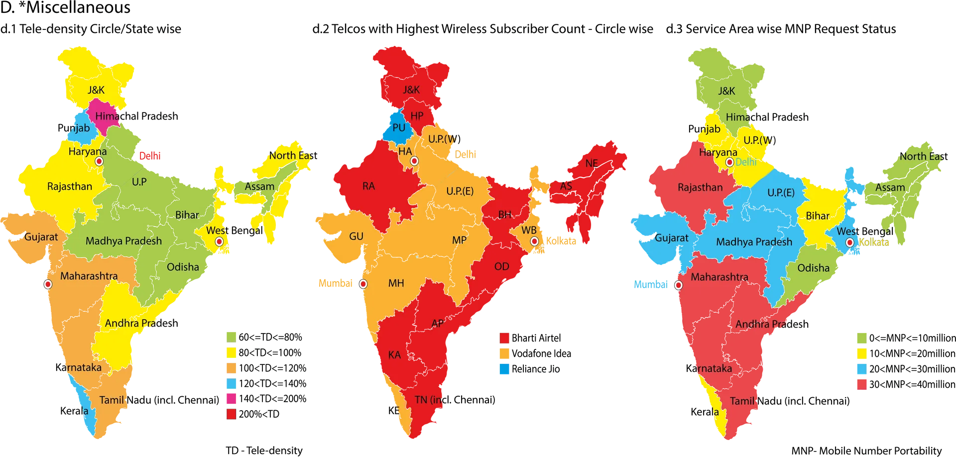
Image details 4997 × 2390 · PNG · Dark grey
Size and format
- Resolution
- 4997 × 2390 pixels (4K Ultra HD)
- Megapixels
- 11.94 MP
- Aspect ratio
- 21:9 · Landscape
- Best for
- Desktop and laptop screens
- File format
- PNG
- Transparent background
- Yes
Colour
- Dominant colour
- Dark grey
- Main colours
- Teal
- Colour tone
- Warm
- Brightness
- Medium
- Contrast
- Medium
- Saturation
- Vivid
- Black and white
- No
- Colour palette
- Dark grey73%Crimson8%Orange6%Black5%Yellow4%Lime green3%
Content
- Style
- Vector art
- Subject
- India map
- Mood
- Educational, clear, informative
Edit India Telecom Data Comparison Maps PNG
Browse all PNG tools ›








Related India Telecom Data Comparison Maps PNG
-

India's Taj Mahal Mirrored Perfectly PNG -

Sunset In Taj Mahal India PNG -

Indian Desi Girl Digital Art PNG -

Indian Pillars In Palace PNG -

Yamuna River In India PNG -

Boy With Indian Flag Art PNG -

India's Taj Mahal In Mist PNG -

Foggy Taj Mahal India PNG -

Ruins In India PNG -

Mountain Top With Indian Flag PNG -

Flag Of India Galaxy PNG -

Indian Flag Painted On Wall PNG -

India's Taj Mahal With Sunset PNG -

Indian Army With Flag PNG -

Indian Flag With Blue Sky PNG -

Indian Building Vector Illustration PNG -

Munshi Ghat India PNG -

Akshardham Temple India PNG -

Caption: Majestic India Gate Monument in Delhi, India PNG -

Indian Air Force PNG -

Taj Mahal In India PNG -

India Taj Mahal With Camels PNG -

Colorful Necklaces In India PNG -

Indian Women Oil Painting PNG -

Indian Woman Bindi PNG -

Gold Ganesh Statue In India PNG -

Indian Architecture During Daytime PNG -

India Mood Board PNG -

Architectures In India PNG -

Indian Temple And Berry Trees PNG -

Aesthetic Indian Collage PNG -

India Gate Art PNG -

Mehndi Indian Hands Art PNG -

Indian Girl Pink Art PNG -

Aesthetic Indian Girl Art PNG -

Beautiful Indian Woman Art PNG


📌 Boards
Build your own collection of png
Boards are free personal collections of wallpapers, backgrounds, PNGs and SVGs. Keep them private or share with one click.
Get this on your phone
Scan with your phone camera to open this page.